- Collection:
- New Georgia Encyclopedia
- Title:
- Freedom Rides Map
- Creator:
- AP Newsfeatures (Firm)
- Date of Original:
- 1961
- Subject:
- Southern States--Maps
Civil rights--Southern States
African Americans--Civil rights--Southern States
Civil rights movements--Southern States
Civil rights demonstrations--Southern States
Segregation--Southern States
Freedom Rides, 1961 - Location:
- United States, 39.76, -98.5
- Medium:
- maps (documents)
- Type:
- StillImage
- Format:
- image/jpeg
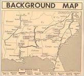
- Description:
- This map shows the routes of numerous Freedom Rides that took place throughout the South from April through December 1961. The rides were intended to test compliance with federal court rulings barring segregation in interstate travel. Freedom Rides were a successful tool in advancing the cause of civil rights.
Image of a map showing the routes of numerous Freedom Rides that took place throughout the South from April through December 1961. The map also highlights the numbers of arrests at certain locations throughout the South. The rides were intended to test compliance with federal court rulings barring segregation in interstate travel. Freedom Rides were a successful tool in advancing the cause of civil rights. - Metadata URL:
- https://www.georgiaencyclopedia.org/articles/history-archaeology/freedom-rides/m-10861/
- Rights Holder:
- Map by Associated Press Newsfeatures
- Additional Rights Information:
- Please contact holding institution for information regarding use and copyright status.
- Original Collection:
- http://www.georgiaencyclopedia.org/articles/history-archaeology/freedom-rides
Forms part of: New Georgia Encyclopedia - Contributing Institution:
- New Georgia Encyclopedia (Project)
- Rights:
-
